Informational
North Shore Oahu Flooding March 2026: Kona Lows, Wahiawa Dam Alert & Surf Impacts
Mar
Photo courtesy of: local10.com
North Shore Oahu Flooding March 2026: Kona Lows, Wahiawa Dam Alert & Impacts on Surf Breaks
Published March 21, 2026 | Hawaii.surf Editorial Team
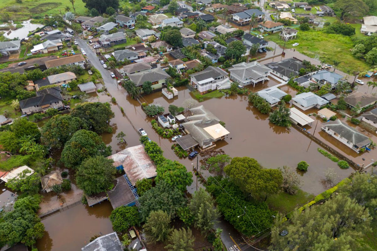
The Seven Mile Miracle is underwater. As of Saturday morning, March 21, 2026, Oʻahu’s North Shore remains under flash flood warnings, with evacuation orders still in effect for parts of Waialua and Haleiwa. The Wahiawa Dam crisis has stabilized for now — reservoir levels peaked at ~85.3 ft early Friday (triggering imminent failure alerts) but trended down to ~83.7 ft by midday Friday and are holding stable — yet officials stress the situation is not resolved, with more rain forecast through Sunday afternoon. Evacuation orders persist, and residents are urged not to return until official all-clear.
This back-to-back Kona low event (the second in less than a week on already saturated ground) has caused catastrophic flash flooding, road closures, rescues (over 230 reported), power outages (~4,200 North Shore customers), and potential $1 billion in damage, per Gov. Josh Green. Here’s a breakdown of what happened, impacts on the surf community and iconic breaks, historical context, and what surfers/residents need to know right now.
What Happened: Timeline of the Storm
The flooding intensified overnight Thursday into Friday, March 20, as a second Kona low dumped 6–12 inches (up to two to three months’ worth of rain in 24 hours) across northern Oʻahu. Low-lying areas like Haleiwa, Waialua, and Mokuleia were overwhelmed early Friday, with alerts at 3:42 a.m. urging trapped residents to move to highest levels. Sirens blared, firefighters/lifeguards used jet skis and surfboards for rescues, and videos showed vehicles submerged and homes pushed off foundations.
The Wahiawa Dam (built 1906, high-hazard potential) rose to within inches of the 84–85 ft evacuation threshold by 4:30 a.m., spilling over at high rates. An “imminent failure” notification was issued ~8:30 a.m., prompting evacuations for ~4,000–5,000 in downstream risk zones. By midday Friday, levels dropped to ~83.7 ft with no breach or damage reported; Dole Food Co. (owner) states the dam remains structurally sound and monitored continuously. Evac orders remain due to ongoing rain risk.
Sources: Hawaii News Now, Civil Beat, CNN, NWS Honolulu.
What Is a Kona Low — and Why This One Was So Severe
A Kona low is a slow-moving low-pressure system west of the islands, pulling southerly/southwesterly winds and moisture from the tropics — opposite prevailing trades. When stalled or sequential on saturated ground, rainfall becomes extreme. This second system in a week compounded the first’s saturation, leading to rapid runoff, flash flooding, landslides, and road washouts (e.g., Kamehameha Highway sections closed).
Climate trends show increasing intensity/frequency of such events in Hawaiʻi. This qualifies as one of the largest floods in 20 years.
Impacts on North Shore Surf Breaks and Community
Access to the North Shore is severely limited — Kamehameha Highway impassable in multiple sections, Farrington Highway shut, Ke Nui Road flooded. Surf breaks are off-limits due to:
- Contamination & Debris: Red dirt, agricultural runoff, potential sewage from streams flush into the ocean, turning water murky/brown. Pipeline, Sunset, Waimea, and Haleiwa-area spots affected (similar to February 2026 flush). Hawaii Department of Health brown water advisories expected — stay out until cleared (typically 5–10+ days post-flood).
- Debris Hazards: Tree trunks, fencing, household items in water/reefs — life-threatening even post-flood.
- Access Issues: Roads/beach entries blocked; power outages delay inspections.
High surf advisory (10–16 ft north-facing) is irrelevant with these conditions. Water quality clearance from DoH (health.hawaii.gov) needed before surfing. Past events suggest 5–14 days for clearance; sandbar/reef resets could take weeks/months.
[Image: Waimea Bay landslide/debris from recent Kona low – Credit: SURFER Magazine / Adventure Sports Network]Historical Context: Resilience in the Face of Storms
The North Shore has endured Kona lows before (e.g., 2004, 2021), with temporary sandbar shifts, reef debris, and highway damage. Hawaiian watermen long understood the ocean’s duality — same forces creating epic surf can reshape land. Waimea River breaks through sandbars during floods, altering bays. Community kokua (mutual aid) shines: neighbors with trucks, surfers using boards for rescues.
Plantation-era infrastructure like Wahiawa Dam (long flagged for upgrades) highlights ongoing vulnerabilities amid changing climate patterns.
Practical Advice: What to Do Right Now
For Residents in Affected Areas:
- Do not return until Honolulu DEM lifts evacuation orders (check oahuem.com or HNL.gov/alerts).
- Before power restoration: Turn off appliances/breaker; wait for Hawaiian Electric all-clear (call 1-855-304-1212 for issues).
- Avoid floodwater (6 inches can sweep you away); photograph damage for insurance.
- Contact American Red Cross Hawaii for aid/shelter.
For Surfers/Visitors:
- Do not attempt North Shore access — roads closed, breaks contaminated/unsafe.
- Wait for DoH water quality all-clear (health.hawaii.gov/clean-water-branch).
- Monitor NWS Honolulu (weather.gov/hfo) for flood watch (through Sunday afternoon).
- Avoid drones — hampers rescues.
Reliable Sources to Monitor:
How You Can Help: Supporting North Shore Recovery
The North Shore community has always come together in tough times, and this flooding event will require sustained support for recovery. Monetary donations are the most effective way to help at this stage — they allow trusted organizations to buy exactly what is needed (food, cleanup supplies, emergency aid) without the challenges of shipping or storage. Item donations can be useful but should be coordinated with specific requests to avoid waste.
Several established groups are actively responding on Oʻahu. The Salvation Army is conducting statewide disaster relief, providing meals, supplies, and long-term assistance to affected families. Donations go directly to Kona low storm efforts and are tax-deductible.
LāHui Foundation is mobilizing North Shore cleanup crews and coordinating direct support for impacted households. They are accepting monetary gifts to fund resources and volunteer operations, with drop-off points for approved supplies at locations like Kahuku Elementary School. Reach out via their site or email for the latest needs (or visit lahuifoundation.org for more details).
The American Red Cross Hawaiʻi is staffing shelters, delivering food and water, and offering emotional support. They are also urgently recruiting volunteers for ongoing response. Contributions help sustain their work across the islands.
Other options include the Hawaiʻi Food Bank for food distribution to displaced families, and Aloha United Way for coordinated help lines and broader relief. Always use official donation links to ensure funds reach those in need, and avoid unverified campaigns.
For hands-on involvement, LāHui Foundation and the Red Cross are organizing volunteer opportunities such as cleanup and shelter assistance. Check their websites or social channels for sign-up details and current requirements. Mahalo in advance for any support you can offer — every contribution helps our North Shore ohana rebuild.
Looking Ahead: Recovery and When Surf Might Return
The flood watch continues through Sunday; additional rain could reverse dam trends. Recovery phases: roads first, power next, resident returns phased. Surf breaks need dry weather for flushing, DoH clearance, and reef/sand resets — realistically weeks for full normalcy, with possible permanent changes.
Hawaii.surf will update break guides (e.g., Pipeline, Waimea) as info emerges. Sign up for our newsletter for direct conditions/recovery alerts.
This is a developing situation — check official sources for latest. Our thoughts are with the North Shore community. The waves will return; let’s support the people who call this place home.
Hawaii.surf Editorial Team – Covering surf culture, conditions, and community across the islands.